AI is not just software; its data centers, energy demand, water use, and cloud infrastructure create real land-use impacts.
Cities should establish governance, trust, and gradual implementation before scaling AI tools for permitting, resident service, or scenario modeling.
Digital twins can connect GIS, BIM, carbon data, and zoning context to help planners test impacts before development decisions are locked in.
While building departments and municipal planners wrestle with how to use AI as software, they also need to think about how they deal with AI as part of the built environment.
The manifestation of AI is becoming far more physical. The infrastructure it requires consumes land, electricity, water, cooling capacity, fiber optic networks, and staff attention. Local governments have to contend with not just using AI for better outcomes, but also how AI impacts resources and public trust.
At the 2026 National Planning Conference (NPC26) in Detroit, Michigan, three presentations coalesced around the environmental footprint of advanced digital technology. While AI tools, digital twins, and connected data can converge to change planning workflows, resiliency, and de-carbonization outcomes for the better, their infrastructure needs are also changing the physical geography planners must manage.

Building departments planning for AI infrastructure also have to consider their auxiliary resources needs, such as power substations.
The Not-So Hidden Footprint of Cloud Infrastructure
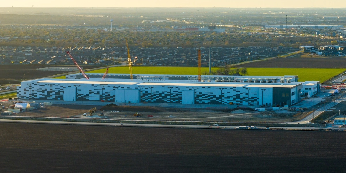
AI and cloud computing infrastructure creates local and regional impacts that municipal planning systems must address. Increasingly divisive data centers and their requirements for power, water, cooling systems, substations, and fiber networks have become part of the local land use conversation. And the growing scale of this buildout is changing what communities need to review.
During the NPC26 panel, “Managing the Land Use Impacts of Artificial Intelligence,” David Morley, Research Program and QA Manager, American Planning Association, noted the significant affect of these massive projects.
“These AI-related infrastructure projects only go back a few years,” Morley says, “and seem to be on track to be the largest infrastructure project, collectively, in US history. We have existing projects on 500-plus acres, and I’ve seen proposals in the pipeline for multi-thousand acre campuses.”
Older data centers might have fit within familiar commercial, office, or industrial categories, but these hyperscale campuses can require years of phased construction, along with large power and cooling capacity commitments.
Such scale turns AI infrastructure into a planning problem for local governments. Large campuses can convert farmland, fragment habitat, increase impervious surface area, generate noise, and shift community identity. Places traditionally identified through agriculture or open land may be asked suddenly to absorb facilities serving a global digital economy.
Beyond just the site, the energy demand can affect local grids, regional generation, utility rates, air quality, and greenhouse gas emissions. Water demand concerns most districts as well, particularly where there’s limited source water or wastewater capacity.
While data centers do not need to be opposed out of hand, their impacts are too specific and large for communities to treat them like ordinary office buildings or industrial parks.
Zoning can help define the use, set standards for noise and setbacks, require studies, manage impacts, and make the review process transparent. However, “zoning has limited tools to address power demand and power delivery,” says Charlie Nichols, Planning and Development Director, Linn County (Iowa), on the “Land Use” panel.
Nichols hit on an important distinction. The systems behind AI’s infrastructure, such as energy markets, water utilities, transmission networks, and environmental impacts, often exceed the boundaries of any single planning department.

Governance Before Scale
Local governments are under pressure to innovate, as the panel “AI Planning for Equity-Sustainability and Resilience” detailed. AI tools have the potential to deliver faster staff workflows, better resident service, more responsive community engagement, and improved data analysis and scenario modeling. Yet the message was clearly not to adopt new tools simply because they are new, but to focus first on what public purposes AI can serve.
Without clear goals, reliable data, ethical standards and public accountability, AI-assisted planning could offer speed while amplifying poor environmental decisions. That’s why David Rouse, Principal, David Rouse FAICP, drove home the point of “establishing an AI governance framework,” he says. “In other words, policies, procedures, and processes for the responsible, transparent, and ethical use of AI in internal operations and functions.”
This is familiar territory for municipal planning, which balances technical information, public values, legal requirements, political constraints, and long-term consequences. AI only makes the need for transparency more urgent. That’s why, on the same panel, Suhag Kansara, Founder and CEO, ViewPro, emphasized starting small with AI implementation. For example: instead of building an all-purpose government chatbot, a planning department might begin with a tool that answers only a few high-volume questions, such as what zoning district a property is in, and what can be built on that property.
“Going slow and easy is really important,” Kansara says. “We ended up creating a chatbot that answers only five questions.” If those few questions are important, and the chatbot always gives correct answers, it can be more valuable than a chatbot that tries to answer everything and frequently fails.
That limited scope is a trust-building strategy, rather than a weakness. Defined workflows that connect to reliable systems, such as GIS and zoning data, allow agencies to validate data, observe user behavior, improve responses, and avoid new maintenance burdens. AI tools, whether used for resident engagement, plan implementation tracking, permitting support, scenario analysis, or public communication, can scale only after they prove useful.
“Planning with AI is about people and community first, technology second,” Rouse says.

Digital twins can combine zoning controls, GIS data, BIM data, and real-time metrics to create a valuable source for shared municipal decision-making.
Digital Twins for More Efficient Digital Planning
As the “Digital Twins for Decarbonizing Development” panel discussed, the same community-first message applies to digital twins for municipal planners. Whether for a building, a development, or an entire city, a planning digital twin can connect GIS, 3D models, zoning controls, environmental data, and performance metrics.
“Digital twins connect people and systems around a shared understanding of the real world,” says Christine Ma, Digital Twin Strategy Lead/Professional Services, Esri.
They can show project reviewers how development decisions may affect carbon, mobility, fiscal outcomes, air quality, solar access, or other local priorities and move environmental analysis upstream, integrating sustainability earlier.
Decarbonization often considers energy use, electrification, materials, insulation, and systems at the building scale. However, buildings do not operate in isolation. Their carbon impacts depend on the grid, transportation patterns, land use, infrastructure, and other factors.
The same building design can perform differently depending on the surrounding district. A low-carbon building connected to a dirty grid, isolated from transit, or embedded in a car-dependent land use pattern would not be the same in a different context.
“In general, land use decisions and planning decisions are essentially carbon decisions,” Ma says.
Digital twins can help planners see these connections earlier and to test scenarios before plans, policies, or approvals are finalized.
“BIM tells us how a building behaves, and GIS enabled digital twins tells us whether that behavior actually works within the neighborhood context,” Ma says. Together, building models combined with city context can help planners evaluate how projects interact with infrastructure, regulations, climate goals, and community priorities.
Of course, digital twins are not a panacea. Carbon modeling depends on data quality, professional judgment, and collaboration across planning, building science, architecture, engineering, energy, ecology, and policy departments.
Digital twins do not automate judgment, but they make data assumptions visible, trade-offs comparable, and decisions easier to communicate. “There is no magic button to spit out carbon outputs,” Ma says. “The quality of outcomes depends directly on the accuracy of standards and assumptions.”
A Carbon-Aware Framework for AI-Era Planning
Considered together, these NPC26 presentations demonstrate a layered approach to city planning. It incorporates planning both with advanced digital technology like AI and digital twins, and planning for the infrastructure that cloud computing, big data, and AI require.
The first is infrastructure awareness. Communities should understand the physical infrastructure behind AI, including data centers and their necessary power, water, cooling, transmission, fiber, and land conversion.
Supplying those needs at scale requires governance and trust. Planning agencies can shape policies for the data that AI tools use, the decisions they allow AI tools to make, human oversight, and AI transparency toward the public.
Lastly, the scenario intelligence possible through digital twins, GIS, BIM, AI-assisted analysis, and planning automation can help communities test land use, zoning, infrastructure, and carbon outcomes before physical construction locks in those decisions.
Data connects all those layers, and the “Digital Twins” panel stressed data’s importance for keeping these digital systems “alive,” rather than static.
“The biggest thing from that perspective is the need for good data,” says Andrew Buck, Senior Urban Planner and Technologist, VHB, “having it available and updated on a regular basis.”
In this new era, the city planner needs not to be a data scientist, energy modeler, AI engineer, or utility operator, but to connect those domains to public values and local decisions.
That’s where Nichols says traditional planning tools like zoning can make complexity more understandable. “Use the zoning process to condense all of that information into one set of meetings for people,” he says. “That is really a hidden power of zoning.”
Making complexity understandable enough for communities to act may be key to city planning in the AI era. In the here and now, AI is part of the planning system. It is part of shaping land use, infrastructure, energy, water, public service, and decarbonization. The future is neither anti-AI nor blindly pro-AI, but rather a transparent, governed, measurable, and carbon-aware inclusion of advanced digital technology.
Successful communities will likely be those that balance the planning of AI-related infrastructure, while using responsible digital tools to shape more equitable, resilient, and lower-carbon localities.